On July 30, 2025, at 5:40 p.m. IST, a historic milestone in space exploration was achieved with the successful launch of the NASA-ISRO Synthetic Aperture Radar (NISAR) satellite from the Satish Dhawan Space Centre in Sriharikota, India. The Geosynchronous Satellite Launch Vehicle (GSLV-F16) started its countdown at 2:10 p. m.on July 29, 2025, propelled NISAR into orbit, marking a significant achievement for the collaborative efforts of the National Aeronautics and Space Administration (NASA) and the Indian Space Research Organisation (ISRO). This mission is poised to revolutionize Earth observation, providing critical data to address global challenges in climate change, disaster management, and environmental monitoring.
A Technological Marvel for Earth Observation
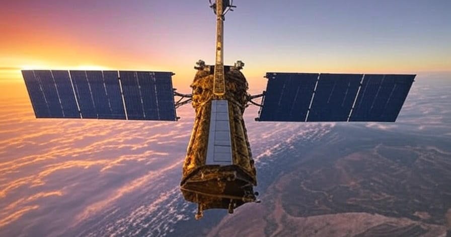
The NISAR mission is distinguished by its advanced dual-frequency synthetic aperture radar system, operating in both L-band and S-band frequencies. This cutting-edge technology enables the satellite to produce high-resolution images of Earth’s surface, regardless of cloud cover or time of day, offering a significant advantage over traditional optical imaging systems. With a revisit cycle of approximately 12 days, NISAR will provide consistent, near-global coverage over its three-year mission, generating a comprehensive dataset for scientific research and practical applications.
By capturing subtle changes in land surfaces, ice sheets, and vegetation, NISAR will contribute to a deeper understanding of natural and anthropogenic phenomena. Its ability to penetrate snow, ice, and dense vegetation makes it an invaluable tool for studying hard-to-access regions, such as polar ice caps and tropical forests.
Addressing Climate Change and Environmental Challenges
One of NISAR’s primary objectives is to enhance our understanding of climate change and its multifaceted impacts. The satellite will track critical indicators, including glacier retreat, sea level rise, and shifts in vegetation patterns. For instance, NISAR’s radar can measure ice sheet dynamics in regions like Antarctica and Greenland, providing data on ice loss rates that are crucial for predicting future sea level changes. Similarly, its ability to monitor deforestation, agricultural productivity, and soil moisture will support global efforts to address biodiversity loss and ensure food security.
These datasets will empower scientists and policymakers to develop evidence-based strategies for mitigating climate change. By providing consistent, high-quality data, NISAR will contribute to international initiatives aimed at achieving sustainability goals and fostering resilience in vulnerable ecosystems.
Enhancing Disaster Preparedness and Response
Beyond climate research, NISAR’s capabilities extend to disaster management, a critical need in regions prone to natural hazards. The satellite’s high-resolution imaging can detect ground deformations as small as a few centimeters, enabling early warnings for earthquakes, volcanic activity, and landslides. In countries like India, where monsoons frequently cause flooding, NISAR’s ability to map flood-prone areas and monitor soil moisture will improve forecasting models and disaster response strategies.
These applications are expected to have a transformative impact on disaster preparedness, particularly in developing nations where resources for risk mitigation are often limited. By providing timely and accurate data, NISAR will enable governments and organizations to reduce the human and economic toll of natural disasters.
A Model of International Collaboration
The NISAR mission shows how working together across countries can help make big scientific discoveries.NASA contributed the L-band radar, a high-data-rate communication system, and the satellite’s primary structure, while ISRO provided the S-band radar, the GSLV-F16 launch vehicle, and mission operations support. This partnership leverages the strengths of both agencies, combining NASA’s expertise in radar technology with ISRO’s proven capabilities in satellite launches and mission management.
The collaboration strengthens bilateral ties between the United States and India, building on ISRO’s impressive track record with missions like Chandrayaan and Mangalyaan. It also sets a precedent for future joint endeavors, demonstrating how shared resources and expertise can address global challenges.
A New Chapter in Space Exploration
The successful launch of NISAR marks a moment of pride for both NASA and ISRO, as well as the global scientific community. As the satellite settles into its polar orbit, it will soon begin transmitting data that promises to reshape our understanding of Earth’s complex systems. Researchers worldwide will have access to this wealth of information, which will inform policies and innovations in environmental management, disaster response, and climate adaptation.
The NISAR mission underscores the critical role of space technology in addressing humanity’s most pressing challenges. By combining advanced technology with international collaboration, NASA and ISRO have set a new standard for Earth observation, paving the way for a more sustainable and resilient future.